Wednesday 29 August 2012

Great Northern Adventure! Part IV

July 31
Ilha de Mocambique - Pemba = 407 km

Won’t lie – Pemba originally wasn’t in our plans. We had another, closer, beach lined up for the last leg of our journey. But while enjoying our time in Ilha the conversation went something like this:

Emily: Woooo! We’ve done five provinces in less than two weeks!
Val: We’re so awesome! In fact, there’s only one province in the entire country I haven’t been to now.
Emily: Me too! And it’s…
Emily & Val: Cabo Delgado!
(*moment of silent realization and plotting*)
Emily: So…how do you feel about Pemba?
Val: Let’s go! Woo!

Thus, we found ourselves on the side of the road in a truckstop of a town called Namialo early the next morning (after two rather unfortunate chapas incidents involving so many people the cobrador couldn’t shut the door and a box of fresh crabs), back to doing our boleia dance for cars to Pemba. While waiting, we called up PCV Ellen and Christine, whom we’d never met before and whose numbers we’d gotten from PCV Patrick and whose house we’d be staying at the next couple of days.

We landed a sweet private car straight to Pemba with a businessman from Nampula and quickly passed out. I was just awake enough to see the sign right before a large bridge that read “Provincia de Cabo Delgado.” At which point, three years after stepping foot in Moz, I had officially visited every province in the country. Finally. I’ll tackle the states next.

The boleia dropped us off in town and after a lunch of beans at the market, we hopped a chapa to Ellen and Christine’s place. They work and live at a teacher training school, and so their house is outfitted not only with all the essential furniture (fridge, stove, pseudo-couch, etc.) but a room with two sets of bunk beds. PCV Derek was also in town to get some work done (his site, two hours down the road, doesn’t have electricity). We chilled at their place the rest of the afternoon and walked down to a restaurant called FrangoAssado (Grilled Chicken) for dinner. Complete with two options on the menu (chicken with xima, or chicken with rice), a full fridge and no silverware, it’s a chicken joint after my own heart.

August 1 & 2

The next two days were spent relatively the same way – here, a 20-minute walk from Ellen and Christine’s place. It was us, the sun and water, boys selling chocolate bars, and our books and a year’s worth of People magazines (a la Ellen). So here’s all you really need to know:


PCV Derek in a palm tree.


found him on the beach. he moves.


homemade HotWheels


August 3

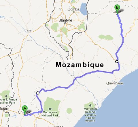
Pemba – Alto Molocue = 613 km


We leave Ellen and Christine’s before dawn and walk to the main road. We have a vague plan to get as far as we can to PCV sites and finish up in Chimoio the day after that. After an hour, we catch a private car with a gentleman headed a few hours down the road. At that town, we settle for hopping into the back of an open back chapa headed to Nampula. Despite the potholes, bumps and wind as we cruise down the road, I manage to bury myself in Lonesome Dove and not think about how far we have to go.

In Nampula four hours later, Emily and I take a detour to get apas – a fried egg folded in a tortilla-type wrap and drizzled with sauce, only available in select places in the north. We catch a chapa to the edge of town and wait for an hour before settling for sharing the front seat of a large truck that pokes along around 40 mph.

We arrive in Alto Molocue after dark to find the two PCVs who live there – education PCV Sam (who had site visited with me during training back in Chokwe last November) and health PCV Dylan. We head back to Sam’s after a quick chicken dinner and Emily and I crash on his makeshift couch-bed for the night.


August 4

Alto Molocue–Chimoio = 809 km

Sam sees us off around 5 and we hike through the hilly streets back to the main road. It’s 7:30 before we finally catch a private pick-up going to Macuba and climb in the back. In Mocuba we barely start to boleia when a couple of gentlemen from Maputo stop by and we chat the next couple of hours to the turn-off in Nicoadala, where one road goes to Chimoio and the other to Quelimane, the provincial capital of Zambezia. Here we have the great fortune to flag down a chipper Spanish family and stretch out in the bed of their pick-up.

On the way, we stop for a photo-op at the Arvore Milagroso. The lady in the front seat, who has a bit of a beard, tells us thatthis particularly tree is incredibly rare and drops only one leaf each year. If you climb up and tear one off yourself, she says, the tree bleeds.

We continue with the family until Gorongosa Park. We’re dirty and disgusting from so many hours in the back of vehicles, but still having a good time and knowing that we’re only a few more hours from our own beds (as much as I enjoyed snuggling with Emily and various other PCVs throughout the trip) where we can sleep in past 5 am.

At Gorongosa we manage to shove our way into a chapa and I spend the next two hours with my arms pinned against me, the cobrador standing over me and so many legs underneath me I’m certain I’m standing on someone’s feet the whole trip but can’t see them to know and don’t have anywhere else to put them anyway (it’s okay, they go numb quickly and then you don’t have to worry about it until you try to stand up). Back in Inchope, we immediately get a ride inside a private truck that drops us off at the Peace Corps office an hour later.

We walk home. Though it’s after dark in the coldest month of the year in one of the coldest cities in Mozambique, I take a cold shower just to be able to have running water, which I haven’t experienced since Malawi. I wash over 600 kilometers of road dirt off and don’t shut off the shower until the water running off my feet is clear again.

However, we only have about an hour. Two friends of ours, a British couple, are leaving Moz to head back to the UK, and we’re having a good-bye party at their place. In an hour, we manage to magically transform ourselves from dirty hippie-zombies to civilized party-going human beings again. It’s right around the corner from my house, so we walk there, and afterward return to my place along with PCV Shane to avoid their having to pay for taxis home. Finally, we pass out in my enormous bed, but inevitably are awake around 6 the next morning.

Grand total: 3899 km

Until the next adventure!


Monday 20 August 2012

Great Northern Adventure! Part III

July 27

Cape Maclear - Cuamba = 279 km
Sometimes I lie awake at night and dream about driving a private car.

And on this particular Friday morning, I awoke from such a dream to climb into the back of a pick-up with 12 other people a a massive box of dried fish on the way back to Monkey Bay. At one point, a lady even tossed her bundled baby into  my lap so that she could climb over people to get in (thankfully, she took him back after only a couple not-so-subtle reminders). From Monkey Bay we caught a chapa to Mangochi, and in Mangochi (after realizing the open-back chapa was practically empty and therefore not leaving for quite some time, we had a godsend – literally, we got a boleia with two Italian nuns. Religious boleais are almost as good as South African boleias: they don’t lack for funding and so have top-notch vehicles with seatbelts and A/C, and while they might not buy you things as South African are prone to do, they usually drive very safely.  On the way, we had even better fortune to spot a congress of these along the side of the road...

(Stole this from Google image. But this vaguely resembles the mental image I took. Close enough.)


A boleia in the back of a bread truck, another bike taxi across the border and we were back in good-ole Portuguese-speaking Moz.

At which point we boarded the Open-Back from Hell. Hell, because I imagine Heaven as being a very clean place, and this was the exact opposite.

I have never in my life been dirty to the extent that I have in Mozambique. At the end of this particular day, I would take a bucket bath where the bath pooling around my feet was so brown I couldn’t see my toes. But that’s later; at this point in the story, it was simply me, Emily, Annie, a looooooong stretch of dirt road and the open sky.

The trees and bushes along the side of the road looked like they were carved from copper because the layer of red dirt was so thick on them. You could feel the dirt hitting you and sticking to the mixture of sunscreen and sweat on your skin. You could write words on your forehead simply by rubbing with your finger (lasts about thirty seconds, then turns brown again). And God forbid you have an itch because your fingernails fill with all kids of indescribable gross when you scratch. When Emily took off her sunglasses at the end of it all, it looked like she’d had a particuarly intense session in the tanning bed. This is what dirty means. And this is how we sat for four hours (minus the ten minutes where we stopped because our driver hit and killed a goat crossing the road and he had to run back and pay the goatherder).

When we finally arrived in Cuamba, Emily and I said tchau to Annie, who was catching another chapa back to Gurue. The two of us then sought out lunch and the train station, our plan being to spend the night with PCV Jama and hop the 5 am train to Nampula the following morning.

The train arrives anywhere between 15h and 19h, and it is only then that you can buy your tickets. Emily and I planted ourselves in front of the ticket window around 16h and passed the time reading, resting, dreaming of showers, and chatting with fellow travelers we met – a young couple doing a sub-Saharan Africa tour from France, and a middle-aged couple traveling Mozambique from Spain. And we waited, as the plaza slowly filled up with people.

I’m still not certain how people knew the train was coming. But all at once, there was a mad rush for the ticket window. People don’t really believe in lines, so it’s just kind of however many people can mass into a marked area and then force their way through whatever means to the destination, be it ticket window, chapa door or ATM. We had worked out a plan, and while Emily raced for the throng.

Thankfully, before the even started selling the tickets, I receive a message from Jama saying that she was friends with the station master, had reserved our tickets, and needed only to find and pay him to get them. So I moved in the opposite direction of the throng, found the man who was quite amiable, and had the tickets in my hand before the ticket window opened. This is why PCVs are awesome.

Once we got our tickets, we found our way to Jama’s house, where she and PCV Zacarias had already prepared dinner. I finally rinsed that layer of dirt of my skin. And we crashed in bed.


July 28

Cuamba - Ilha de Moçambique =531 km


Think Hogwarts Express. Think the Orient Express. Think AmTrack. And then think that it hasn’t had a change of upholstery or anything else for about thirty years. That is the train that runs from Cuamba to Nampula.

We arrived at the train just before 5 (and remember, this is the middle of winter). Passing by the cargo cars, you could see people moving things around in the dark using the light their cell phones. Emily and I splurged for second-class tickets, which meant we were in a compartment. I could just make out four other gray-ish shapes in the light from the train station coming through the window in compartment G – our cabin mates.


We snuggled into our cozy compartment for the 11-hour ride, most of which was spent chatting, reading, sleeping, snacking and watching the mountains fly by the window. By far the best way to travel in Moz.

The villages along the train track seemed only to exist because of the train. Each place we stopped would already have a crowd of people, and not just to board. Instead, people flocked to the windows with baskets and buckets on their heads piled high with fruits, veggies, cokes, water, whatever, to sell.

Unfortunately, a large number of the vendors were kids, which made the whole money/goods exchange out the side of the window a bit tricky.


The other tricky part made me wish that I hadn’t bought the bottled water from that kid… I didn’t take a picture of the bathroom, but allow me to describe: closet with hole in the bottom. A decent-sized hole at that, big enough to lose your leg in if you’re not careful. When you first enter, it’s actually a bit mesmerizing to watch the tracks fly by through the hole. But then you get over the fascination when you realize this is absolutely all you have to work with. And then begins the fun task of bracing yourself against the walls over said hole, trying to maintain both your balance and your aim as the train bumps along the tracks while trying not to think about all the others who have attempted (some without success, as is plainly marked) the same before you.

We arrived in Nampula around 17 and walked to the chapa station with the Spanish couple to catch a chapa to Ilha de Mozambique. The magical transport with plenty of space, cushy seats, and food walking up to the window was gone. But not before an obligatory train photo was taken.

And we were off to Ilha.


July 29

First, a bit of history about Ilha de Moçambique…

Ilha is known for being the first place in Moz colonized by Europeans, but it was actually an Arab port before that. In fact, the island and subsequently the country got its name from an Arab trader, Musa Al Big. In 1498, the Vasco de Gama of fifth-grade history class legend arrived and Ilha became the capital of the Portuguese East Africa company, which traded in slaves, spices and gold.

The Portuguese have long since been chased out and the tiny island’s 14,000 current inhabitants are 95% Muslim, but the fort, hospital, churches and narrow streets that look like they fell straight out of Europe still stand. The island is reached via a 3km bridge from the mainland, and can be traversed end-to-end in a little over an hour. It’s so narrow that in places without buildings, you can do a 180 and see both shores.

I’m pretty sure even de Gama himself wasn’t as excited as I was about finally arriving in Ilha.

The end of the island closest to the bridge, Makuti, is full of traditional Moz-style houses (cinder blocks and tin roofs). The entire neighborhood sits a few meters below the road, as this area was stripped of stones to build the fort and town on the ritzier end. Emily and I crashed with PCV Patrick on this side of town, and set out the first morning for the side known as “Stone Town.”

Most of the streets that cut through the multi-story, multi-colored stone buildings are barely wide enough for cars. Some of the buildings are well maintained, with bright shutters on the windows and flower pots on the tiny balconies. Others, however, have been home to only squatters for so long they’re literally caving in on themselves.


The old governor’s place – complete with statue of de Gama out front – is a museum, now in the process of being rehabilitated. Emily and I stopped by the palace to purchase our tickets to visit the Fortaleza São Sebastião. The fort was built between 1558 and 1620 and is the largest European fort in Sub-Saharan Africa.


A guard just outside the entrance took our tickets, then Emily and I had free reign to poke around in the old soldiers’ barracks, chapel, officers’ houses, kitchen, firing wall, etc. And perhaps a sunken ship at the edge of the slave auction site?


We also found that, after the fort ceased to be used and prior to being named an UNESCO protected site, other people had seen fit to utilize the area for different purposes.


"trancas," i.e. where people go to get their hair did


Beyond that, the fort was in surprisingly good repair. At least, enough that you could let yourself imagine what it must've been like to arrive at the fort a few hundred years ago.

Hidden in a corner of the fort is another gem: the Chapel of Nossa Senhora de Baluarte. Constructed in 1522, it’s considered the oldest European building in the southern hemisphere. The previous inhabitants were even still hanging on in the walls. It seriously felt like we’d somehow fallen through a rabbit hole and out of Africa altogether.


"Brother Fern...???"

But then we went and ate matpa de siri-siri – matapa (see previous entry) made with seaweed – and all was right with the world.


Afterward we wandered around (literally, we pretty much walked the circumference of the island) til we found a nice spot on the water to park it, read our books, and watch the sun set.


July 30

Have I mentioned that a perk of crashing with PCVs is that they always know people? The next morning, PCV Patrick (who apparently has a lot of guests…) called up a friend and Emily and I set off for a cruise on a dhow boat.

What distinguishes a dhow boat, you ask? Imagine if Gilligan and his crew had built a sail boat – without the help of the professor.

It’s essentially a wooden hull with slats across the middle to sit on. The “mast” is made of a series of long, thin poles lashes together with once-colorful rope, and they hoist it up using only a primitive pulley system that involves only more ropes. The mast itself is a patchwork of off-white canvas. One guy sits in the back guiding the hand-carved rudder, and the other one hops around directing and tying the sail. During launch and landing, you as a passenger might be asked to sit on different sides of the boat several times to help out the whole balancing process. In fact, for most of the ride back, one of our guides had to perch himself on the end of a stick wedged into the hull and hanging a good three feet over the water in order to balance us out.


Once the sail was tied down and we started cruising toward the mainland, Emily and I were free to kick back and dip our hands into the water as we sailed back to the mainland.

The place we landed, though back on the mainland, can only be reached by boat. Our guide took us across the thin peninsula to the open ocean on the other side. There was a tide pool just over a small hill, and this is where we broke out the snorkel gear PCV Patrick had lent us and dived in.

The pool was only about 30 meters across and of varying depths and mostly covered with vegetation at the bottom. And it was FULL of fish.

My favorite sighting? This guy:


Again, stolen from Google because my camera doesn't take kindly to water.

After exploring every inch of the tide pool, we wandered to the open water and spent the afternoon swimming, snorkeling, reading and sun bathing before our guy found us and took us back to the island.

We wrapped up the day meeting with two newly arrived PCVs, Megan and Caitlin, and Patrick at a rooftop restaurant. Emily and I split a giant lobster which they prepared over a charcoal fire a few feet away. Then we crashed in bed to get ready for the final leg of our trip: Pemba.

Wednesday 15 August 2012

Great Northern Adventure! Part II

July 23
Gurue, ZambeziaàMandimba, Niassa = 317 km
The next day was not quite so pleasant. At 4:30 in the morning, Annie, Anna, Emily and I snuggled together in the back of a friend’s pick-up for the brief, frigid ride to the chapa stop in town. Bags in tow, we piled into the chapa and waited for it to fill complete up (chapas don’t leave until all 15 seats are filled with 25 people). After a few hours we were able to stretch our (now numb) legs in Cuamba before we got on another chapa to Mandimba, on the border of Malawi.  We arrived shortly after noon and went to the currency changing station (the place where the guys with huge wads of cash stand around and shout “American dollar! American dollar!” as you pass). The rate from the Malawian kwacha to the Mozambican meticais is about 10 to 1. The meticais to the American dollar is about 27 to 1. But if you didn’t know that, this would look incredibly impressive:
In Mandimba, we planned to stay with PCV Kyla. When we arrived, she said she was one town over waiting for a chapa to leave. So we sat down to have lunch and wait.
Lunch turned into afternoon snack.

Afternoon snack turned into dinner.

Dinner turned into late-night drinks.

And after countless games of King’s Corner, Solitaire, Snake on the phone, and anything else we could think of…we continued to wait.

It’s Mozambique. After three years, you just kind of roll with it.
Kyla finally arrived after 22 and we headed back to her place to crash on a mattress on her floor. Which was great because the next morning…


July 24
Mandimba - Cape McClear, Malawi = 129 km

When you don’t have a car at your disposal, you get really creative about modes of transportation. But by far the coolest mode of transportation in Moz: the bike taxi.

Which is exactly what it sounds like: you pay a guy (who hangs out in packs on the main street, much like the reputable money-changers) to take you somewhere on his bike. The bikes are perfectly outfitted for such endeavors – the metal square behind the seat normally reserved for transporting boxes of gin and goat is covered with a pad suitable (though not recommended) for sitting, and the pegs on the back wheel are reinforced to allow you to put your feet on them. While in transit, you are encouraged to hang onto your seat, or pretty much anything other than your driver. Biker. Whatever. And you comfortably sit and take in the view and try not to be offended when the biker starts huffing and puffing and having to stand up when you go up a slight incline. It’s really quite pleasant.
We said our farewells to Kyla and Anna and hopped on our respective "taxis." The ride to the Moz border took about 20 minutes. After having our passports stamped, we boarded our bikes again and crossed the gate into No Man’s Land, similar to the Demilitarized Zone between Romulan and Federation space. The ride between the two country’s gates took another 20 minutes, before we found ourselves getting our passports stamped again and surrounded by more (aggressive) bike taxis, money changers and people speaking what they claim is English.

After paying our taxis, we moved on to the next mode of transportation. Please note: we had very credible sources (other PCVs) advise us on traveling to Cape Maclear. One of the most important things they stressed was transport price “negotiation.” So when we went to the chapa (an open-back truck with a few people already on), the conversation went like this...

Annie: How much to Mangochi?
Driver: 1000 kwacha.
Annie: No, it's 500.
Driver: Ok, 750.
Annie: No, it's 500.
Driver: No, best price, 650.
Annie: It’s 500.
Driver: No, it’s 650!
Annie: It’s 500.
Driver: Okay, it’s 500.

And we get in and wait for them to drive the exact same 500 meter loop five times to pick up more people before we actually start in the direction of Mangochi.
The official languages of Malawi are Chichewa and English. Which means the government is run in English and everyone really speaks Chichewa except for when they see white people who they assume speak English and want something from them. However, in the back of the truck, we were pleased to find a Malawian that also knew Portuguese and amused ourselves by learning Malawian English.
Us: How do you say “capulana” in English?
Him: “Fabric.”
Us: Oh, wow! Fabric! What about “cobrador?”
Him: “Money collector.”
Us: Brilliant! And how do you say “boleia” in English?
Him: “Lift.”
Us: Whoa!

Unfortunately, we were also distressed to discover that they could also partly understand our English. I’m kind of ashamed to admit that Moz PCVs take it for granted that no one around them speaks English, so when we’re together we typically don’t filter our conversations as we should. (i.e., “Whoa, the man sitting next to me seriously smells like my latrine!” etc.) So, in this case, we simply reverted back to Portuguese. (i.e., “Epa, este homen ao meu lado cheira como minha latrina!”). It also made interesting reads along the way, as we passed the “God First Warehouse” and the “Fear Allah Market” and other such fun stores.
From Mangochi, we caught another chapa to Monkey Bay, and from Monkey Bay found a pick-up going to Cape Maclear. We arrived at the backpacker’s in the late afternoon. We put down our bags and stretched out for the view at our lodge on the shore of Lake Malawi.


July 25
Lake Malawi (Lago Niassa on the Moz side) is Africa's third largest lake and the eighth largest lake in the world. More interestingly, it's said to be home to more species of fish than any other freshwater body in the world. And on top of all that, it's absolutely gorgeous.
Cape Maclear is situated in a small peninsula on the southern end. The village is filled with backpackers and lodges along one main road, yet it’s still a relatively undiscovered and so doesn’t feel like a tourist destination. Walking along the beach, you’d pass the typical lodges with bars and wicker furniture and hammocks and landscaping – and then pass a fence and suddenly be in someone’s back yard, where women were busy washing clothes, dishes and children in the lake water. Alongside the kayakers, you’d see canoes made of hollowed-out logs and filled with fishermen and nets.
On one side of the road were the lodges with high fences and gates and signs that read “Guests only,” and on the other side it looked like the bush, with the addition of giant Baobob trees.

Another PCV characteristic is that we pride ourselves on not being tourists or just passing visitors – we live here, doggonit, and in Moz we expect you to treat us like any other Mozambican and address us in Portuguese (it’s a nice dream, anyway). So it was a little bit of a shock when we realized that people could speak pseudo-English to us, then turn to each other and speak Chichewa and we’d have no idea what they were saying. Oh yeah – suddenly, we were just more white tourists.
But we embraced it while walking around the small town and settled for learning “thank you” in Chichewa (“zikomo”). In the afternoon, we rented kayaks and snorkel gear from a nearby lodge and set out for an island less than a kilometer from shore.
After a lap around the island, we pulled our kayaks on shore and dove into the shallows. If you have never been snorkeling or scuba diving, I encourage you to do so. There’s simply nothing quite like hanging out in the water, alongside tons of gorgeous and brilliant fish, and just being a part of the underwater world for a while. Sadly, there are no pictures of this part.
After watching the sunset on the water, we returned to the lodge for potato skins and a chicken dinner before crashing in bed – around 9 o’clock.

July 26
Our final day in Cape Maclear was passed mainly eating delicious bean burrito-type dishes you can’t find in Moz and in perusing the jewelry and crafts in the countless stalls along the main road. One gentleman with a Bob Marley-type hat over his dreads tried to sell us his very own line of “Happy Pants,” and proceeded to sing us his Happy Pants Man jingle. I admire his marketing strategies, but got the impression his happiness had very little to do with pants.

In addition Malawi’s fine tourist-geared cuisine, we also sampled the country’s brew. One, Carlsberg, is a Danish beer bottled in Malawi. It’s light, refreshing, and sold for 250 kwacha.
The other, the true Malawian brew, is sold in 1-liter milk cartons for 150 kwacha and tastes like liquefied fermented dirty socks. And also vaguely resembles it. Called Chibuku, you are encouraged to shake it before drinking, and if you wait too long the milk carton-esque container starts to swell with the excess gas. We all took an obligatory sip and promptly chased it down with something else more fit for human consumption. Like, pretty much anything.
Overall, not a bad life on the shores of Lake Malawi.


Saturday 11 August 2012

The Great Northern Adventure! Part I

During the school’s winter break, my sitemate/now roommate Emily and I decided to take a little trip up to Malawi and the Mozambican provinces we had yet to visit. Armed with a backpack each, a jar of peanut butter and no solid plans, we took off on the morning of July 21 on an excursion of more than 3,900 km - our Great Northern Adventure!

Part I

Chimoio, Manica - Gurúe, Zambezia = 814 km


July 21

We got up at 2:40 in the morning (careful not to wake the three sleeping people and one sleeping dog also crashing at my house that night) and headed to the chapa stop to see about buses north. They only had standing room on the big buses leaving at 3:30, so we opted instead for a small chapa to take us to the main road where we could boleia. Go figure, there’s not a whole lot going on at a chapa stop at 3:30h – at least nothing we wanted to be a part of – so we settled for finding our chapa and snuggled into the backseats to asleep until more people showed up and we left at 5h. Around 6:30, we arrived in the town of Inchope on the National Highway 1 (EN-1), which starts in the southernmost province and capital and stretches to the northernmost. After doing our boleia dance (flapping our hands at oncoming cars and looking desperate) on the side of the road for an hour, we had the great fortune to land a Chinese business bad English and worse Portuguese. Which didn’t deter his conversation and frequent chuckles at all. With limited vocabulary, a lot of gestures and five hours on the road, he told me about his work with cotton in Moz, how he misses his family and hopes to go back home (the Xindan province…?), and then explained that one of the songs we listened to (in between the Chinese boybands) was a song of praise (he broke out the English/Chinese dictionary on his BlackBerry and showed me the word – “Buddhism”). He turned off the road in the village of Zero (no joke) and Emily and I resumed our dance until a bus with two open seats pulled over around 13h. We settled in with books and iPods for the next few hours, until we got down at our turn-off at the electricity-less truck stop village of Nampevo around 18:30h. We walked to our next boleia spot using the light of our cell phones and the moon, where we had the incredible fortune to catch a small truck headed our way. An hour and a half later he told us that we were coming up on the village of Invinha, just outside the city of Gurúe, where fellow PCV Annie lived. Annie had given us directions to her house ahead of time (Invinha doesn’t have cell phone service), but we had been in town all of two minutes when we saw a flock of mzungos headed for the car – four PCVs. They had dinner ready and waiting for us, and after catching up we finally snuggled into the house’s two beds – for Emily and I, a difference of about 20 hours and 800 km from where we’d started the day.

July 22

Gurúe is renowned for its rolling hills covered with chazeiras - tea plants. It sits at the base of Namuli Mountain, the second largest in the country, and this and the waterfalls make it a superb hiking destination. As such, the six of us got up the next morning to check it out for ourselves. We hopped a ride on a truck transporting wood (pokey sticks…ow), about 20 other people and a bike.
As luck would have it, the truck ended up taking a shortcut that got us way off track and hopped off in the middle of one of Gurúe’s endless tea fields . (“Peace Corps – never the adventure you think you’re going to have,” Allison says.) With the help of our good friend Buffalo (who we picked up on the side of the road), we decided to try to find a lake buried on some random trails.


After a detour through a bamboo forest (seriously , it’s like CandyLand: Africa Edition), we found it!


We hiked back into town to meet up with another PCV, Julia, and have an early birthday celebration involving red velvet cake and puppies. Seriously, you simply can’t beat that. Happy Birthday Julia!

We hopped in the back of a pick-up moving furniture for the 20 minute ride back to Annie’s house and said farewell to the gorgeous Gurúe and its infinite tea.


back row: Anna, me, Emily, Allison, Caitlin, Annie
front row: Julia and friends